Everybody can remember, at least once, their frustration with an “inaccurate” weather forecast. The truth is that, even in our age of supercomputers, weather forecasting is still a major challenge. Dynamics and evolution of weather systems is an equation with too many unknowns, and there are too many factors that may substantially influence the forecast. Examples are plenty: at the mesoscale, severe thunderstorms and bands of heavy snow are particularly challenging. They constantly evolve, and while there may be a high confidence in the fact that a heavy downpour or a snow storm will happen – precisely predicting the location is a different story in many ways.
For larger, synoptic scale events, it may seem that forecasting should be easier due to the size and inertia of these systems – in particular, hurricanes. However, there are multiple factors that come into play while forecasting the tropical system’s strength. Even more variables can impact the forecast of the hurricane’s track, particularly when it comes close to land. I was always amazed by how much knowledge, skill and experience it takes to forecast weather phenomena – yet how challenging it may sometimes be. Trying to predict the behavior of the Hurricane Dorian is undoubtedly one of these stories.
There are only 35 Atlantic storms in the modern history of meteorological observations (and that’s a century’s worth of data) that have ever reached the strength of a Category 5 hurricane according to the Saffir-Simpson scale. The latest of them, Hurricane Dorian, is making news headlines for the past week. There is a number of reasons why – and the main one, of course, is its factual and potential impact on the Bahamas, Florida and the coastal Southeast of the United States.
Dorian gained the status of the hurricane on August 28th, and rapidly intensified within just a few days after that. However, it was watched carefully even before that, and the confidence grew in its potential major impact on the West Atlantic, just north of the Caribbean. Early forecasts suggested a path affecting Puerto Rico and Dominican Republic – the areas that suffered immensely from the Hurricane Maria in 2017.
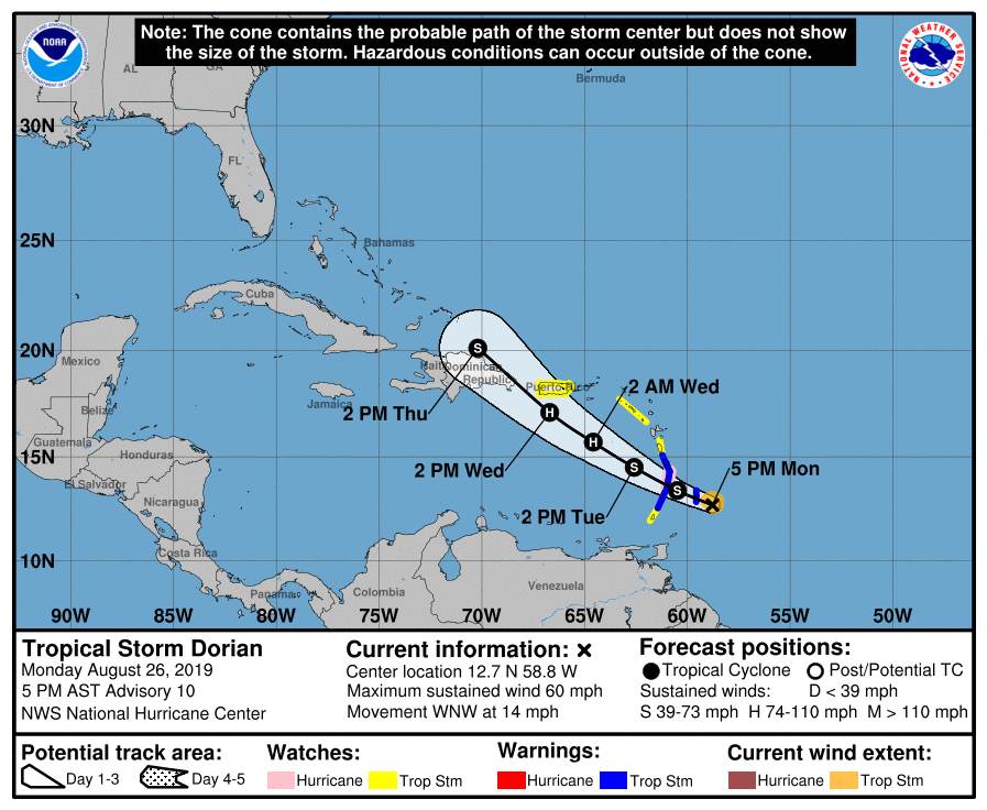
However, luckily Dorian mostly spared Puerto Rico, grazing its eastern part. That was the first twist in its quite remarkable dynamics, that makes it stand out among others from a different, meteorological standpoint. An area of the high pressure that persisted over the western part of the Atlantic Ocean and kept the powerful storm from steering north moved eastward. That gave Dorian an opportunity to curve north, which was reflected in the National Hurricane Center forecasts on August 28th.
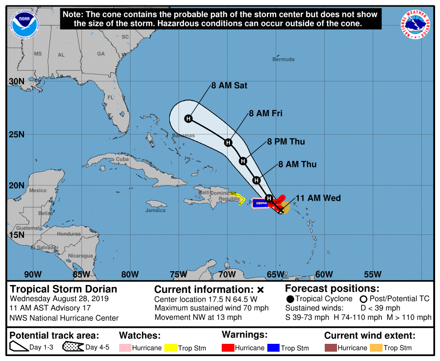
With this curve, the first signs of an almost imminent landfall in Florida triggered an avalanche of watches and warnings, and activated the sequence of emergency preparations procedures on the Florida’s Atlantic coast. Since then, confidence in the possible landfall was growing from forecast to forecast for the next two days, as the hurricane neared the Bahamas. Friday, August 30th, brought the news about Dorian’s potential to grow into a Category 4 hurricane before making landfall on Florida’s east coast.
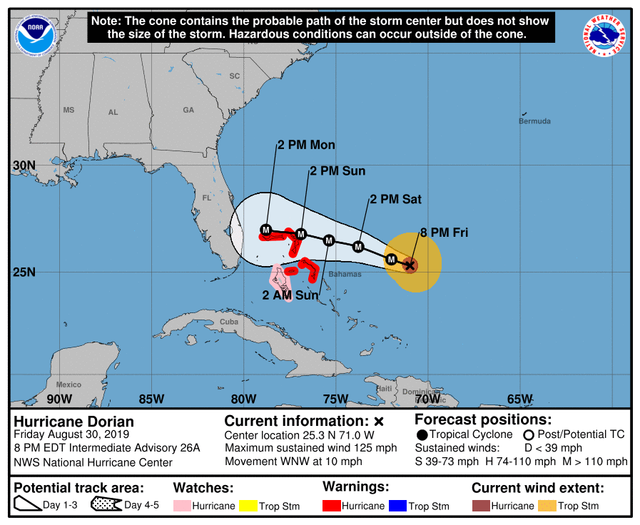
The day later, however, the model consensus started to lean towards another turn in the hurricane’s path. Due to intensifying influence from the Jet stream, particularly from a though moving eastward, Dorian was set to turn away from Florida without making a landfall. While that meant a significantly lesser impact for the Sunshine State, it also implied a continuous journey of this powerful tropical system along the United States’ southeastern coast.
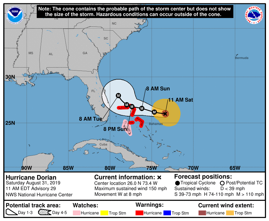
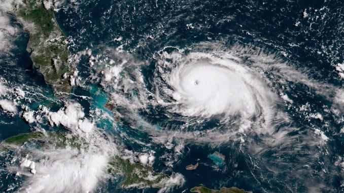
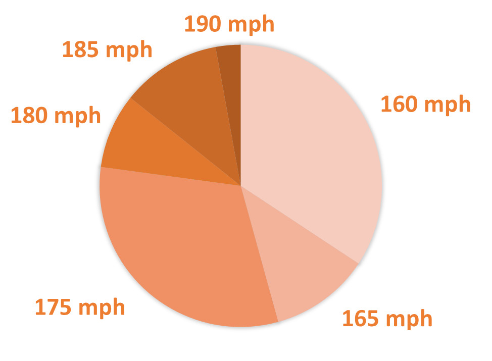
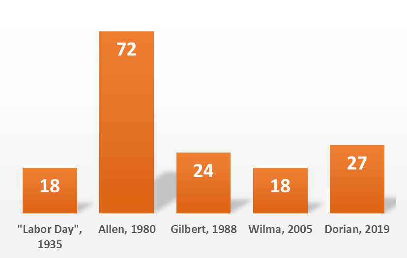
Forecasts of the day before came true on August 31st, when Dorian reached the Category 4 strength. However, it did not stop there: only a day after, on Sunday September 1st, its sustained winds exceeded 157 mph, officially opening the doors into the Category 5 club. At its maximum strength, the sustained winds inside Dorian leaked at 185 mph, with gusts recorded up to 220 mph! These put Dorian among the top hurricanes based on its wind speed: out of the 35 Category 5 hurricanes recorded, only 5 had sustained wind speeds of 185 mph or higher. Among those five, Dorian is also one of the longest-lasting tropical systems, as it maintained the Category 5 wind speeds for the whole 27 hours. (Hurricane Allen that went through the Caribbean and the Gulf of Mexico in 1980 is a different story since it weakened to Category 4 several times, regaining strength after that).
And than brings us to another unique feature of the Hurricane Dorian, the significance of which in the magnitude of damage that it made upon its landfall on the Bahamas, and shortly after, is still to be appreciated. While the violent destructive winds of 185+ mph are already bad enough – the hurricane moved exceptionally slowly, only magnifying the damage. A “typical” major hurricane travels at approximately 15 mph on average. At the time of its landfall on September 1st, Dorian’s speed was barely 5-7 mph, and it decreased to only 1-2 mph upon its approach to the Grand Bahama Island. In other words, the areas in the immediate proximity to the hurricane’s eye experienced winds equivalent to an EF-4 tornado for several hours! Not discounting the damage that resulted from lower, but still violent, winds farther from the eye.
While the Bahamas are starting to recover from the direct hit, major preparations are underway to respond to potential effects of Dorian’s close graze in Florida, Georgia, and the Carolinas. Crews and trucks coming from more than 30 US States are filling the staging areas, and evacuations prompted lane reversals on the I-16 in Georgia and I-26 in South Carolina. Amateur radio operators and emergency volunteers also did not stay aside of the action: the Hurricane Watch Net has been activated on September 1st and is operating 24/7 until further notice. Local amateur radio operators are ready to provide communications support to disaster relief organizations and first responders in the areas where traditional communications may be compromised.
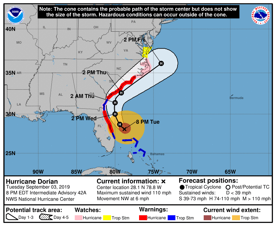
The latest forecasts further support the Hurricane Dorian’s path along the Florida’s Atlantic coast, and up north along the southeastern US. High winds and storm surge will be the main threats that will persist throughout most of this week. Thus, here’s to everyone staying safe in the areas of potential impact, as the story is not yet over.